March 24 @ 5 PM in Northen Auditorium
“Where I am is who I am: Plotting Spatial Demographics in Renaissance Florence”
Prof. Niall Atkinson (Art History, University of Chicago)
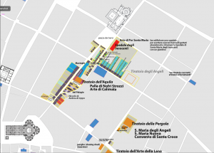
At a time before the advent of a rationalized system of numbered addresses, people in cities understood the places in which they lived their lives as a network of integrated spatial and social relationships between streets, people, institutions, and activities. this was no less true in the case of the first “modern” tax census carried out in Florence, in 1427. Known as the catasto, this massive experiment in developing a demographic portrait of the city required each household to declare where they stood, literally, in relation to the state and their immediate neighbor. By processing these relational stems of address, digital technologies now allow us the ability to build a social map of every Florentine household in the city at a moment when the city precisely at a moment when the city was transforming, experimenting with, and inventing forms of cultural production, economic innovation, and political practices that have had lasting effects on the history of the west. And the visualization of such a map will help us to understand the way in which Florentines understood their collective identity, who they were, as a function of where they were: where they lived, where they worked, where they prayed, and even where they died.